
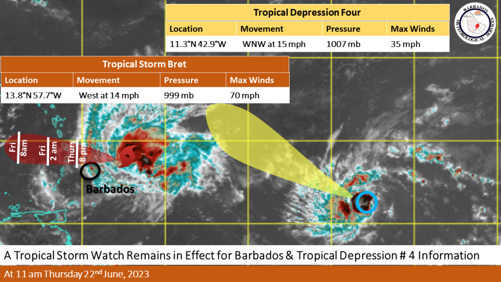
At 11:00 a.m. today, the centre of Tropical Storm Bret was located near 13.8N 57.7W or approximately 130MI (205KM) east-northeast of Barbados. Tropical Storm Bret continues to move westward at 14MPH (22KM/H) towards the Lesser Antilles with maximum sustained winds near 70 MPH (110KM/H) and a minimum central pressure of 999MB.
The centre of Bret and its strongest winds are expected to pass approximately 59MI (95KM) to the north of Barbados late this evening. Regardless of this, winds gusting possibly to storm force are likely during this afternoon and increasing tonight. Wind speeds are expected to range between 25 to 35 mph with higher gusts. Given Bret’s close proximity to the north of the island, a Tropical Storm Watch remains in effect.
Marine conditions will continue to deteriorate today and remain so into early Friday morning. Moderate to rough swells of 2.5m to 3.5m (8 ft to 11ft) in open water around Barbados are expected to generate choppy conditions, which will particularly affect the islands’ eastern and northern coastlines. As a result, Small Craft and High Surf Advisories are in effect.
Mariners are advised not to venture too far from port and secure their vessels immediately.
Outer bands of Tropical Storm Bret will begin to affect the island from tonight with showers and gusty winds. Rainfall accumulations of 1 to 3 inches (25 to 75mm) are likely across the island. This may result in flash flooding in low-lying districts. People in these areas should begin to make the relevant preparations to protect property and life.
The next update will be issued at 2:00 p.m.
Meanwhile, Tropical Depression #4 is also in the Tropical Central Atlantic.
At 11:00 a.m., the centre of the system was located near 11.3N 42.9W with maximum sustained winds of 35 mph or 55km/h. The present movement is towards to west-northwest or 285 degrees at 15mph or 24km/h with a minimum central pressure of 1007MB.
Current satellite imagery shows this system is small and compact.
Conditions will continue to improve for further development into a Tropical Storm in the coming days and it is expected to remain well east of the northern section of the island chain.
The system has been tracking slightly north of west with an increase in forward speed expected during the next few days followed by a turn toward the northwest over the weekend.
There are no watches or warnings in effect for Barbados with respect to this tropical depression.
However, due to the location within the Central Atlantic, the public is urged to continue monitoring official sources.


More Stories
Stolen cow recovered in Joe’s River Forest
Resilience and Sustainability Trust to be reviewed
Barbadians urged to be prepared for hurricane season