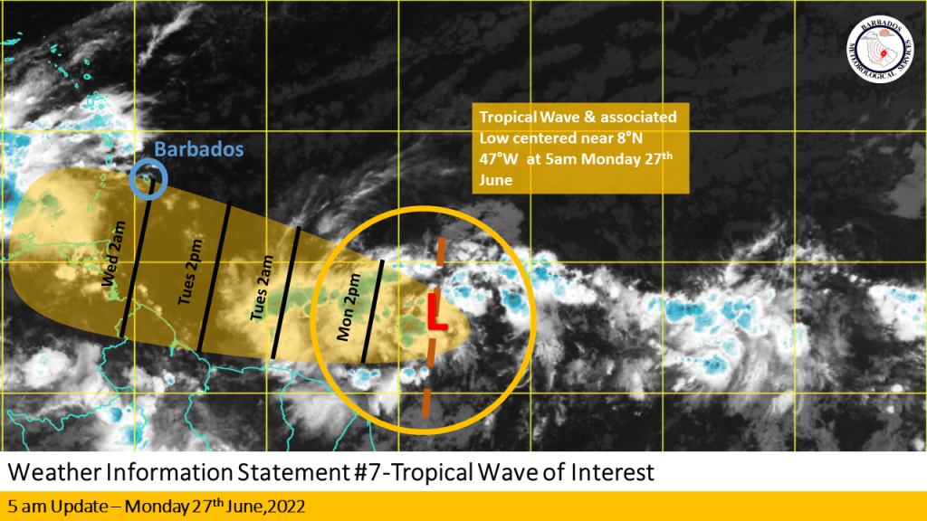
The Barbados Meteorological Services continues to closely monitor the progress of a tropical wave near 47W and associated low pressure centred near 7N 47W some 1480km ( 920 miles) east-southeast of Barbados at 5 AM.
The system remains disorganised and convection has been sporadic throughout the night as it continues to track westward near 17 mph(28km/h). This general westward speed has increased during the night and is expected to continue today. Conditions appear favourable
for further development and a tropical depression could form in the next few days as the center tracks south of the island. Regardless of
development, BMS is urging the public to be ready and to remain on the alert for messages from this department and the Department of
Emergency Management today and Tuesday.
Excess rainfall, severe thunderstorm and wind alerts remain elevated to yellow level for
tomorrow, Tuesday 28th June 2022. This means that the public should be aware that there is the POSSIBILITY of adverse weather conditions on Tuesday. A small craft advisory remains in effect for above-normal sea swells until Wednesday evening.
GOES 16 Infrared satellite imagery and current model guidance suggest the vortex remains elongated despite an increase in convection
overnight. Environmental conditions continued to improve overnight and will continue into today, which should give the system the opportunity to tighten up its elongated circulation. A NOAA hurricane hunter aircraft is expected to investigate the system during the afternoon.
As a reminder, kindly follow official sources of alerts for Barbados issued by the Barbados Meteorological Services through the CAP.CAP or the BMS insight app.
The next update will be issued at 5 PM Monday, 27th June 2022.


More Stories
Bulls one win away from BABA title
Renewed efforts to deal with monkey population
Barbados joins several other countries recognising Palestine