
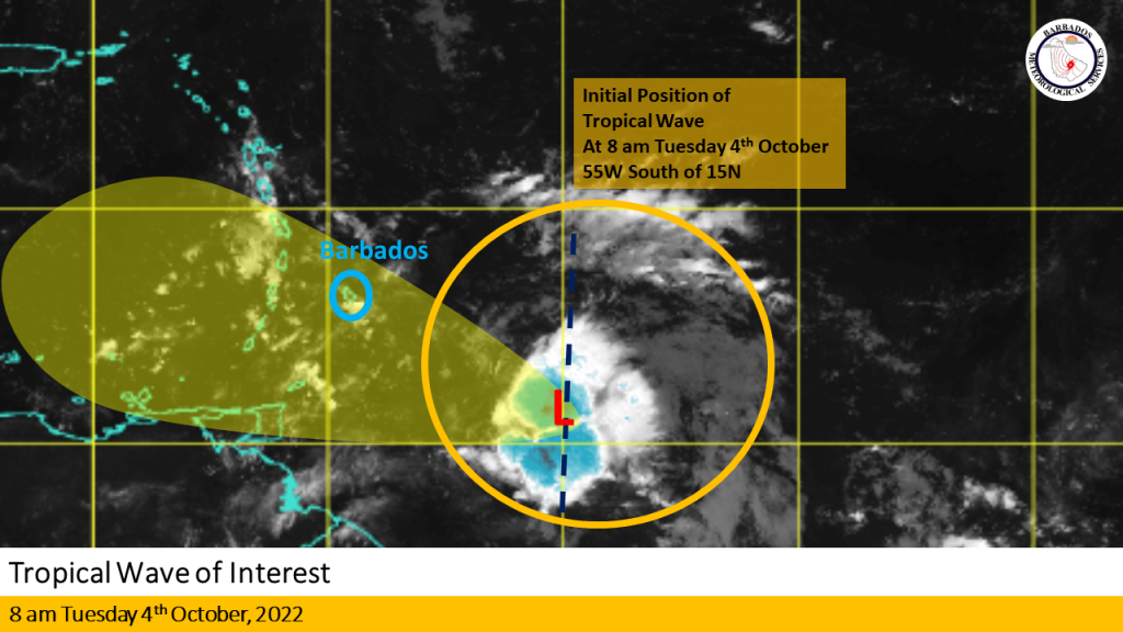
The Barbados Meteorological Services continues to closely monitor the progress of a tropical wave located near 55W south of 15N at 8 am today, Tuesday, October 4, 2022.
Current Situation: Overnight deep convection increased near the center of the mid-level circulation, located near 10.5N 55W. This is about 580 km (360 miles) east southeast of Barbados. The system remains disorganized, however deep convective development is expected to continue over the next 12 hours.
Intensity Forecast: Conditions will be marginally favourable for some slow development throughout today as it approaches Barbados and the Windward islands. During its passage across Barbados and the Eastern Caribbean, environmental conditions are expected to be less conducive for tropical cyclone development.
Track Forecast: The system is expected to track west to west-northwestward at 10 to 15 mph over the next 12 to 24 hours. This should bring the system into our area tomorrow, Wednesday, October 5, 2022.
Special Note: Regardless of development, this wave in combination with an upper-level trough could produce 1 to 2 inches of rainfall with isolated higher amounts of 3 inches in moderate to heavy showers. Winds are currently predicted to range between 20 to 30 mph with higher gusts near showers.
Recommendations to the public:
Stay alert for updates from the BMS on this system over the next 12 to 24 hours.
The next update will be at 12 Noon today Tuesday, October 4, 2022 or sooner if conditions warrant. (BMS)


More Stories
Road concerns addressed at St. Joseph Speaks
Traced: Donishia Keanna Thomas
Equipping youth to tackle climate change