Barbadians should brace for some showers and possible isolated thunderstorms tomorrow, Sunday, June 26th, 2022.
The Barbados Meteorological Services says this is due to a tropical wave.
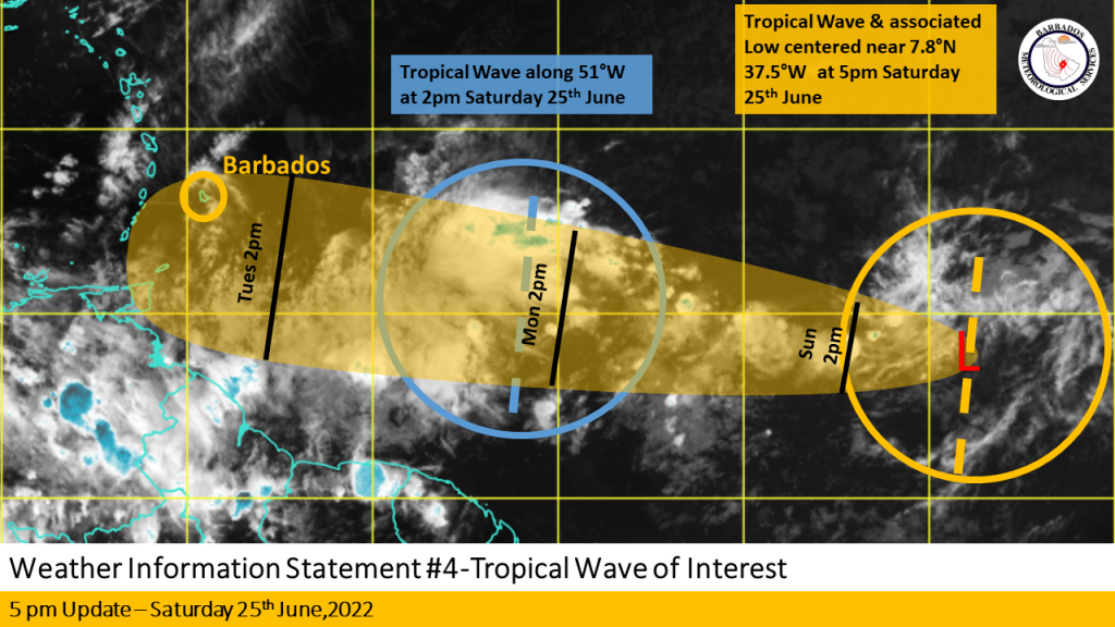
This weather is however not associated with another tropical wave the BMS has been closely monitoring, which at 5:00 p.m. was located near 37W or about 2475KM (1540 miles) east of Barbados.
The BMS says this 2nd wave has remained disorganized throughout the day as it lacked deep convection near or around the centre. It says since this morning, the system has been tracking westward near 15 mph (24km/h) and this general westward to slightly north of westward motion with an increase in forward speed around Monday is expected.
Some slow development is expected over the next few days and a tropical depression could form sometime early to mid next week.
Regardless of development, the BMS is urging the public to be ready and to remain on the alert for messages from the department and the Department of Emergency Management over this weekend and in particular on Monday.
Marine, excess rainfall, severe thunderstorm and wind alerts remain elevated to yellow level for Tuesday, June 28th, 2022 – meaning that there is the possibility of hazardous weather conditions in the next few days.
The BMS will issue its next update at 6:00 a.m., tomorrow, June 26th, 2022.


More Stories
Guyana: Gov’t promises no increase in electricity bills
Grenada: Police seize large quantity of marijuana
UWI stay undefeated in BFA