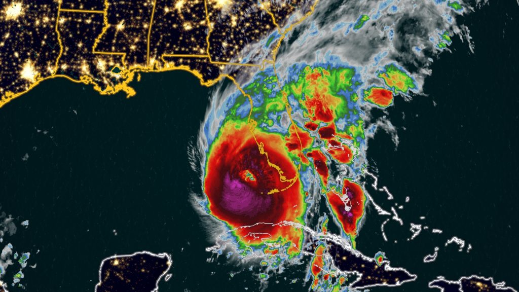
(CNN) — Hurricane Ian made landfall along the southwestern coast of Florida near Cayo Costa around 3:05 p.m. ET Wednesday with winds near 150 mph, making it a strong Category 4 hurricane, according to the National Hurricane Centre.
The storm is delivering a catastrophic trifecta of high winds, heavy rain and historic storm surge to the state and is set to cause significant power outages and flooding as it moves at a slow pace across central Florida over the next day or two.
Hurricane Ian is tied for the strongest storm to make landfall on the west coast of the Florida peninsula, matching the wind speed of Hurricane Charley in 2004.
Already, over a million Florida utility customers were without power as of 3:45 p.m., according to PowerOutage.us. Officials in Cape Coral and Punta Gorda reported significant impacts, and the storm surge set records for the highest water levels ever observed in Fort Myers and Naples.
“The storm surge is very significant. We’re seeing cars and boats float down the street. We’re seeing trees nearly bent in half,” Frank Loni, an architect from California staying in Fort Myers Beach for the storm, said midday Wednesday. “There’s quite a bit of chaos on the streets.”
Water levels in Fort Myers have risen more than 6 feet over the past seven hours and still rising as strong winds continue to push water from the Gulf of Mexico ashore, according to CNN Meteorologist Brandon Miller.
“I’ve been here since the mid-70s, this is actually — by far — the worst storm I have ever seen,” Fort Myers Mayor Kevin Anderson told CNN’s Jake Tapper.
The Collier County Sheriff’s Office, south of Fort Myers, reported people being trapped in their homes, according to the department’s post on Facebook. The Sheriff’s Office said it’s in “call triage mode” and getting numerous calls of people trapped by water.
“Some are reporting life threatening medical emergencies in deep water. We will get to them first. Some are reporting water coming into their house but not life threatening. They will have to wait. Possibly until the water recedes,” the post read.
To make matters worse, the Lee County’s 911 system is down and calls are be rerouted to Collier County Sheriff, according to the post.
“You can’t imagine the calls,” the post read.
The Olde Naples Seaport, a community of condos that overlooks the Naples Bay in southern Florida, has been consumed by storm surge, according to video shot by Graham Pederson. Pederson experienced knee-high water trying to escape.
In another video shot from the second floor, wind is seen whipping trees and trucks nearly submerged by the water. Pederson retreated to the second floor to wait out the storm, his brother-in-law Kyle Wendel told CNN.
Florida Gov. Ron DeSantis requested President Joe Biden approve a major disaster declaration for all 67 counties in the state due to Hurricane Ian, his office said in a news release. DeSantis is also requesting that President Biden grant FEMA the authority to provide 100% federal cost share for debris removal and emergency protective measures for the first 60 days from Ian’s landfall.
Much of west-central Florida and places inland face disaster: “Historic” storm surge up to 18 feet is possible and could swallow coastal homes; rain could cause flooding across much of the state; and crushing winds could flatten homes and stop electricity service for days or weeks.
“This is a wind storm and a surge storm and a flood storm, all in one,” CNN meteorologist Chad Myers said. “And this is going to spread itself out across the entire state. Everybody is going to see something from this.”
Mandatory evacuations were ordered for flood-prone areas on the coast, and the National Weather Service warned those who stayed behind to move to upper floors in case of rising water levels.
“This is a powerful storm that should be treated like you would treat” a tornado approaching your home, Gov. Ron DeSantis said around 8 a.m.
Images showed extensive flooding in coastal neighborhoods in Naples, where officials asked residents to shelter in place until further notice.
In some areas, such as Charlotte County, Florida, 911 response teams have stopped emergency service due to the high winds and dangerous conditions. Sarasota Mayor Eric Arroyo said on CNN’s “At This Hour” that police officers were being taken off the streets due to the wind speeds and hazardous conditions.
“It is too late to evacuate at this point,” Arroyo said.
Ian poses several major dangers:
• Storm surge: Some 12 to 18 feet of seawater pushed onto land was predicted Wednesday for the coastal Fort Myers area, from Englewood to Bonita Beach, forecasters said. Only slightly less is forecast for a stretch from Bonita Beach down to near the Everglades (8 to 12 feet), and from near Bradenton to Englewood (6 to 10 feet), forecasters said.
Lower — but still life-threatening — surge is possible elsewhere, including north of Tampa and along Florida’s northeast coast near Jacksonville.
• Winds: Southwest Florida is facing “catastrophic wind damage.” Winds near the core of Hurricane Ian could exceed 150 mph, with gusts up to 190 mph, the hurricane centre said. Multiple locations, including Sanibel Island, already have recorded wind gusts above 100 mph.
Ian is expected to retain hurricane strength through the day and into tomorrow as the centre of the storm moves northeast over the Florida Peninsula, passing close to Orlando and Daytona Beach, before moving back into the Atlantic Ocean Thursday afternoon. Hurricane warnings have been issued for not only southwest Florida but also much of central Florida from coast to coast.
• Flooding rain: Because the storm is expected to slow down, 12 to 24 inches of rain could fall in central and northeastern Florida — including Tampa, Orlando and Jacksonville. That makes for a top-of-scale risk for flooding rainfall across this area.
“Further weakening is expected for the next day or so, but Ian could be near hurricane strength when it moves over the Florida East coast tomorrow, and when it approaches the northeastern Florida, Georgia and South Carolina coasts late Friday, ” the hurricane centre says.
Prior to nearing Florida, Hurricane Ian pummeled Cuba on Tuesday, leaving at least two dead and an islandwide blackout.
Since then, residents of Florida’s vulnerable Gulf Coast have been boarding up and leaving in droves on congested highways. More than 2.5 million people were advised to flee, including 1.75 million under mandatory evacuation orders — no small ask in a state with a large elderly population, some of whom have to be moved from long-term care centers.
Storm surge already was rising late Wednesday morning — more than 4.5 feet above normal highest tides was recorded before noon in Naples, already higher than the previous record there of 4.02 feet from Hurricane Irma in 2017.
After making landfall, Ian’s center is expected to move over central Florida through Thursday morning. Heavy rain and flooding also is possible in southern Florida, Georgia and coastal South Carolina. The governors of North and South Carolina have already declared states of emergency in their respective states.
Because Ian slowly approached land, the worst conditions could remain over some areas for eight or more hours.
“Widespread, life-threatening catastrophic flash, urban, and river flooding is expected” across central and southern Florida, the hurricane centre said.
By late Thursday, Ian is due to emerge over the Atlantic Ocean, where it could strengthen again and affect another part of the US.
Parts of far southern Florida by early Wednesday morning had begun feeling the storm’s effects, with tropical storm-force winds and at least two possible tornadoes reported in Broward County, including at North Perry Airport, where planes and hangers were damaged. Major flooding was being reported in Key West due to storm surge, along with power outages.
Schools, supermarkets, theme parks, hospitals and airports had announced closures. The Navy moved its ships, and the Coast Guard has shut down ports. As winds pick up, gas stations may temporarily run out of fuel, DeSantis said.
In Tampa, police went door to door Tuesday in a mandatory evacuation zone, making sure residents were ready to flee. Earlier projections had Ian on track to slam Tampa Bay, and even as the hurricane’s path shifted south, mandatory evacuations and preparations continued, Tampa Mayor Jane Castor said.
Law enforcement officials around the state warned that people who stayed behind in evacuation areas cannot expect rescuers to respond to calls for help during the storm when winds are high.
“If you call for help, once we pull (officers) off the road … we’re not coming. … We’re not putting people in peril when (others) didn’t heed the mandatory evacuation order,” Pinellas County Sheriff Bob Gualtieri said Wednesday.
Not everyone moved. Chelsye Napier, of Fort Myers, stayed home with her fiance and cats despite being in an evacuation zone, she told CNN Wednesday. They waited “because we don’t know anyone down here,” and ultimately decided to stay put, she said.
“If anything happens, we have everything that we need here. We’ve got food, we got water. We have everything that we need here,” she said. “So it’s all OK for right now. We’ll see, though, later on.”
Preparations across Florida have been underway for days as residents braced for Ian’s wrath. People lined up to pick up sandbags and flocked to stores to stock up on supplies like water and batteries.
And as the hurricane marched closer, the closures began.
Across Florida, 58 school districts have announced closures due to storm as campuses turned into shelters for evacuees. Disney World is set to close Wednesday and Thursday, as is Kennedy Space Center’s Visitor Complex. And hundreds of Publix grocery stores shut their doors Tuesday evening, expected to remain closed through Thursday.
As millions were told evacuate, 176 shelters opened statewide and hotels and Airbnbs opened to people leaving evacuation zones, DeSantis said.
Local governments and state agencies also prepared those living in nursing homes and other senior care facilities to evacuate.
Florida has around 6 million residents over the age of 60, according to the state’s Department of Elder Affairs — nearly 30% of its total population. As of Tuesday, all adult day cares, senior community cafes and transportation services in evacuation zones are closed, according to the department.
Authorities also readied services to fan out and respond to calls for rescue and then, in the aftermath of the hurricane, for recovery and repair efforts.
Nearly 400 ambulances, buses and support vehicles were responding to areas where the hurricane was expected to make landfall, according to the governor’s office.
DeSantis activated 5,000 Florida National Guard members for Ian’s response operations, and 2,000 more guardsmen from Tennessee, Georgia and North Carolina were being activated to assist.
Florida urban search and rescue teams also were prepping.
“We have five state teams that are activated with additional five FEMA teams that are in play,” Florida Chief Financial Officer Jimmy Patronis said at a news conference Tuesday night. “We have over 600 resources to bear in addition to these out-of-town teams.”


More Stories
More women needed in ICT field
Campbell’s suspension reduced
BNOC workers back on the job