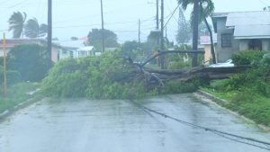
A Tropical Storm Watch remains in effect for Barbados.
In its 8:00 a.m. update, the Barbados Meteorological Services says the forecast track of Tropical Storm Tammy remains relatively unchanged. The centre is still projected to pass north of the island this afternoon.
Additionally, potential impacts expected for Barbados from Tammy remain the same from previous updates.
At 8:00 a.m. the centre of Tropical Storm Tammy was located near 14.0N 58.4W, or approximately 90 miles (150KM) east northeast of Barbados.
Maximum sustained winds have increased to near 65 MPH ( 100KM/H).
Tammy continues to move slowly west-northwestward at 7MPH (11KMH) with a minimum central pressure of 1000 MB.
The BMS says marine conditions have deteriorated overnight with moderate to rough swells of 2.5 m to 3.5 m (8ft to 11ft) in open water. As a result, a Small Craft Warning remains in effect until 6:00 p.m. today and the High Surf Advisory remains in effect for Barbados.
Some occasional light to moderate showers occurred overnight as feeder bands moved across the island. This is expected to persist during the day with shower activity likely to increase this afternoon and into tonight.
The BMS is forecasting rainfall accumulations of around 1 to 3 inches with isolated higher amounts during the passage of Tammy.
Occasional winds gusting to storm force in
moderate to heavy showers associated with feeder bands are possible.
Any intensification of feeder bands to the southeast of the system can result in the watch being upgraded to a warning at short notice.
The public is urged to continue to monitor the progress of this system through updates issued by the Barbados Meteorological Services and follow the guidance and recommendations provided by the Department of Emergency Management.
The next advisory will be issued at 11:00 a.m.


More Stories
Barbadians preparing early for hurricane season
ICC T20 World Cup box office opens in Barbados
Q100.7 FM celebrates important landmark